Stefanie Yeo · · 8 min read
Inside GrabMaps’ proprietary recipe for AI-powered maps of SEA

Summary:
- GrabMaps, Grab’s mapping solution, is no longer just an internal engine; it aims to become the default choice for Southeast Asia map data, offering reliability that the region needs.
- By processing millions of data points in real time from its fleet of driver and rider partners, GrabMaps’ precision and reach powers Grab’s marketplace across Southeast Asia.
- Accurate, AI-powered maps are the foundation of Grab’s services and has also enabled it to bring its mapping expertise beyond the Grab platform to serve both the private and public sectors.
- Download GrabMaps’ Imagery, Places, Roads, and Admin Boundaries sample data to try fresh and accurate maps.
Mapmaking used to be a tedious process, requiring yearslong surveys, highly specialized equipment, and complex mathematical calculations. It was also often a situation of “good enough” as companies settled for map data that wasn’t always completely accurate, especially in regions as geographically diverse as Southeast Asia.
However, modern technology has changed that. Super app Grab is at the forefront of this, leveraging AI and its vast network of driver and rider partners to make mapmaking – and more specifically its mapping service GrabMaps – more efficient, accurate, and up-to-date than ever before.
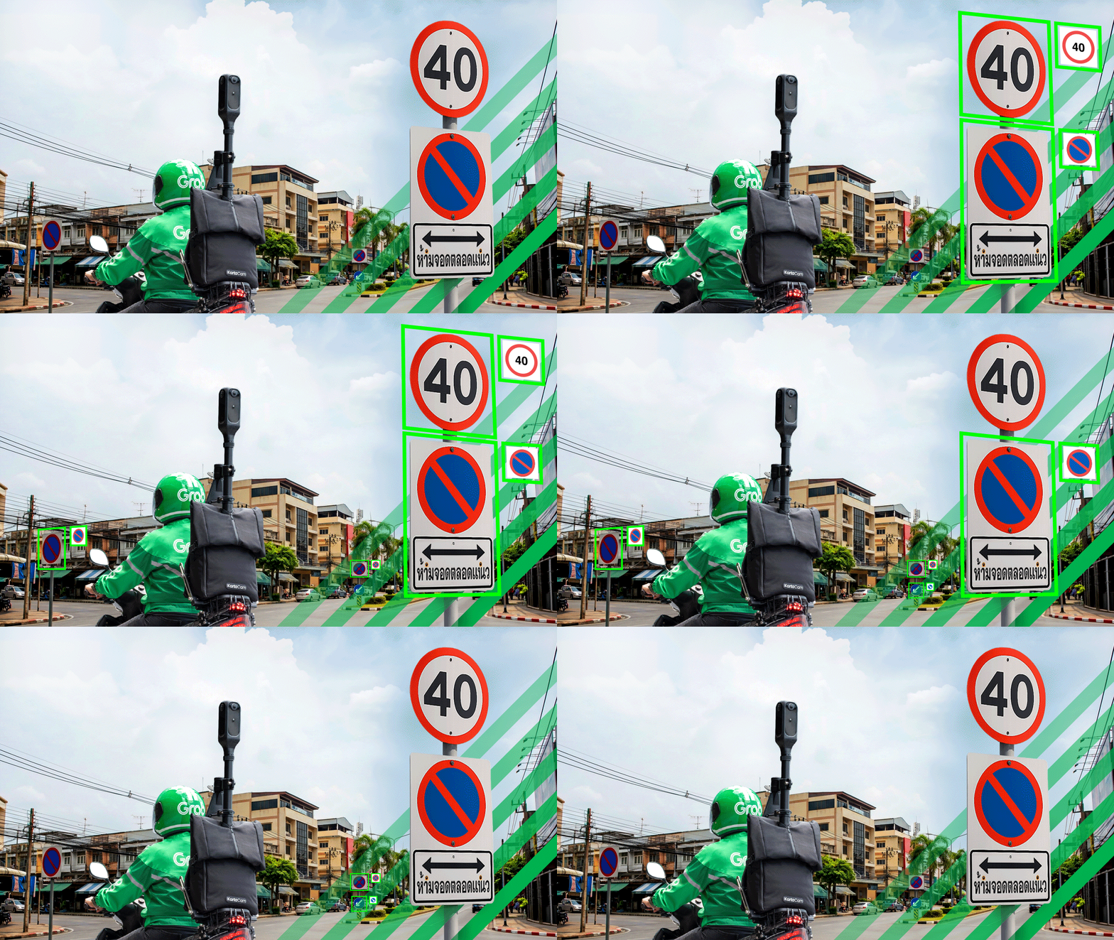
GrabMaps focuses on creating the most hyperlocal and up-to-date maps of Southeast Asia / Image credit: GrabMaps
“AI has been a part of GrabMaps’ process from the very beginning, but what has changed is the amount of AI used and the complexity of the models,” says Adrian Margin, head of data science for geo mapping at Grab.
The value of AI
Having efficient, accurate, and up-to-date maps is crucial for Grab because maps underpin everything it does. The dynamic capabilities of AI can help this process along.
“The most important thing [with maps] is to be able to reflect the needs of the people,” says Margin. “[Southeast Asia is] a dynamic economy, but that creates complexity for our maps. With this use of AI, we are able to fulfill this requirement for everyone.”
A key example is estimated time of arrival (ETA). Traffic conditions can vary wildly – a trip that usually takes 40 minutes could take well over an hour due to a road closure or bad weather. Grab needs to ensure this information is accurate and available in real time to its various partners to ensure the most optimal experience for everyone involved.
Doing so accurately unlocks significant value for everyone in Grab’s ecosystem, creating what Margin calls a “win-win-win situation.”
However, to successfully build accurate maps, Grab needs data. As the amount of information Grab needed for its maps grew over the years, so did the opportunities for AI to make a difference.
Unlocking the power of AI
The true differentiator for GrabMaps isn’t just the AI – it’s the quality of the data being fed into it. Grab goes beyond standard satellite imagery to collect valuable, granular data on the ground itself. Its platform processes over 800,000 GPS data points per second from a fleet of 5 million drivers and delivery partners, helping it create a huge repository of proprietary data.

Image credit: GrabMaps
“We collect many types of data, as well as a significant amount of imagery,” Margin says. Visual data is collected by its KartaCam2 and KartaDashCam, Grab’s proprietary mapmaking devices that were developed in-house. The latter, mounted on the dashboards of Grab’s driver and rider partners’ vehicles, allows Grab to capture street-level changes at a higher frequency, ensuring access to rich and accurate data.
Further, new models can now detect and interpret ground markings, unlocking a new class of information such as lane counts, crosswalks, and dedicated lanes, enabling Grab to make even more accurate predictions by differentiating between different road types and traffic flows.
That said, Grab also needed to find a way to pull together all this information to create a comprehensive map of the markets it operates in, one that is accurate to real-world conditions and which stakeholders could rely on.
That’s where AI comes in.
1. Localization
Grab operates in eight countries and over 900 cities across Southeast Asia. Being able to localize its mapping solution goes a long way in supporting customers and partners in each market.
For example, in countries such as Indonesia, it’s not uncommon to see roads that start off wide enough for four-wheeled vehicles, then progressively get narrower.
“We’ve had situations in the past where the driver [of a car] would drive down such a road, get stuck, and have to drive back several kilometers to find another route,” shares Margin. “That’s not fun.”
AI helps by analyzing visual features of a path to distinguish between roads accessible by cars versus those limited to bicycles or motorbikes.
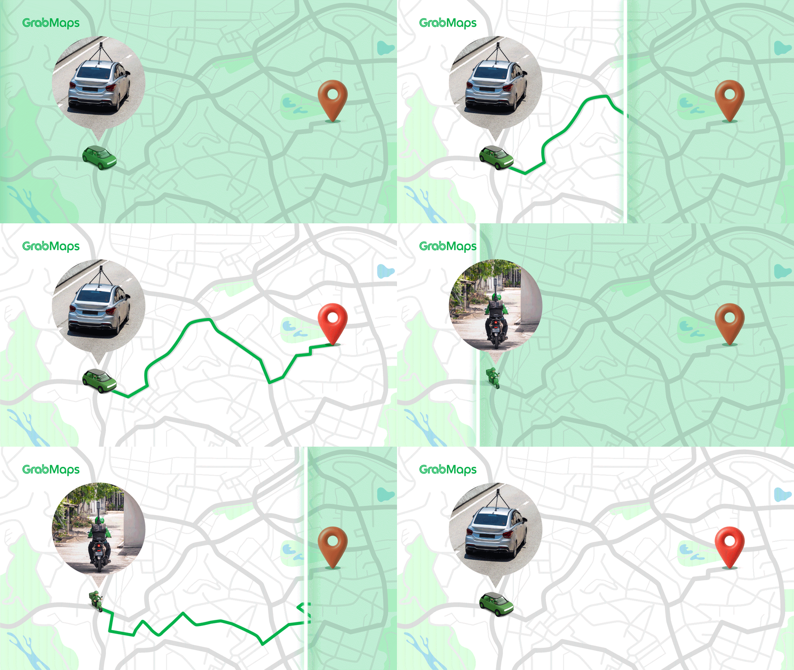
Image credit: GrabMaps
This not only enables Grab to create more accurate maps, but also make route recommendations to ensure drivers take the most optimal path to their destination, unlocking greater efficiency for everyone in Grab’s ecosystem.
2. Freshness and reliability
Another key area where AI has made a difference is in keeping Grab’s maps fresh, especially when there are incidents on the road.
Southeast Asia’s landscape is varied, and constantly evolving. Grab continually collects data on different areas to update its maps, effectively “re-mapping” them to ensure they stay relevant. This helps drivers and riders focus on driving, without having to worry about navigation.
The company relies on information from the KartaDashCam, which has edge AI capabilities, to detect and update the map in response to real-time incidents such as road closures or traffic accidents.
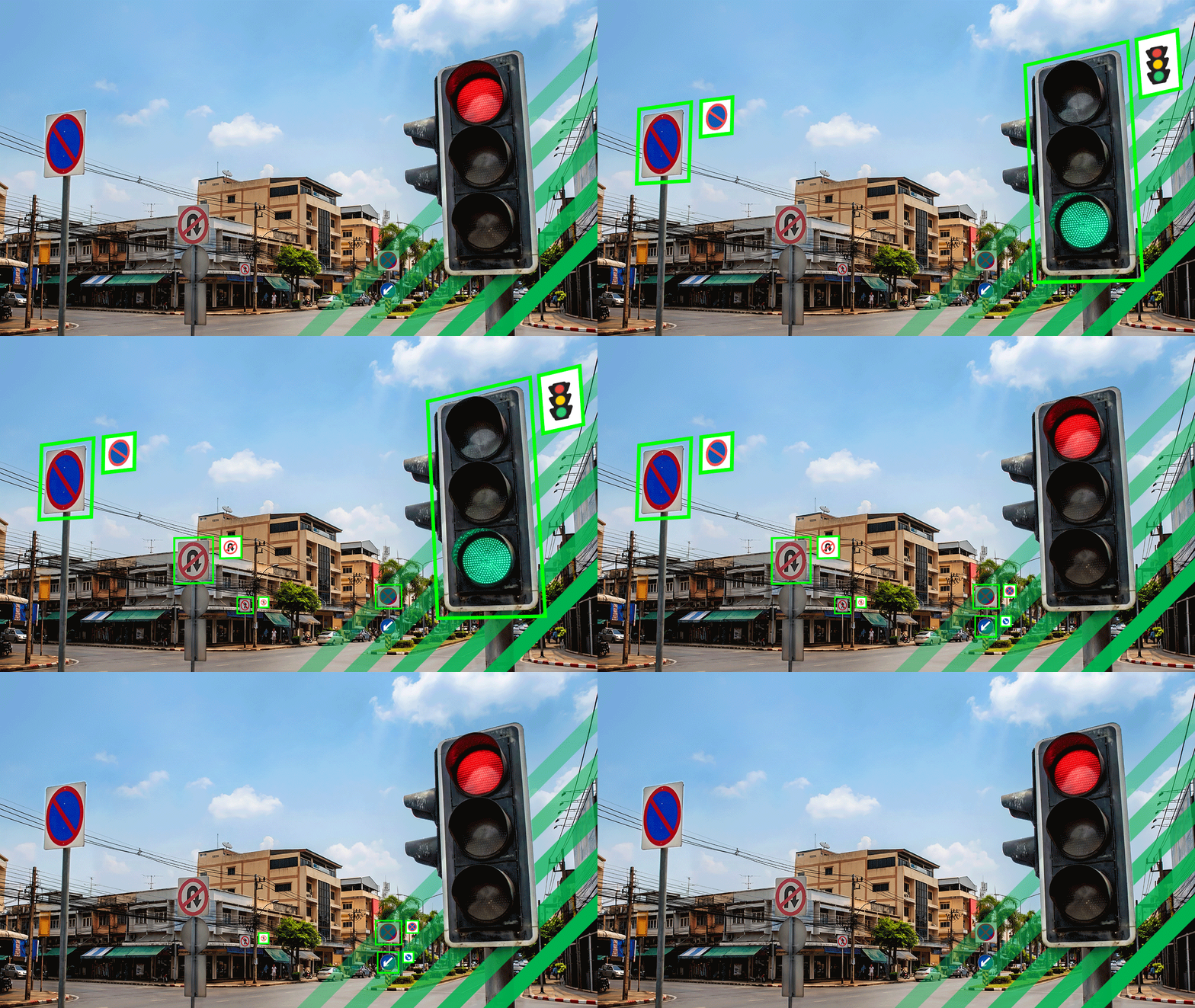
Image credit: GrabMaps
“You cannot send millions of pictures to the cloud daily for processing on the server side, so some of it needs to happen on the camera,” explains Margin.
By processing data locally, the camera only uploads images when it detects a relevant event, like a new road sign or a pothole, allowing Grab to access relevant data at scale while using lower-power hardware.
3. The value of AI
The KartaDashCam can automatically blur out personally identifiable information (PII) on the footage it records, such as people’s faces.
“If PII is visible, there’s limitations on what we can do with the data,” shares Margin. “When that is blurred out, we have more flexibility.”
This gives Grab more data to work with, expanding the possible use cases of the data it has collected, and enabling it to scale up its solutions more effectively.
Grab also has AI models that can automatically extract detailed information from street-view imagery, such as house numbers, to ensure that addresses are correct. It can also distinguish a store name from a street advertisement across a number of Southeast Asian languages, giving Grab even more accurate road data to work with.
“You need AI to achieve that scalability. If you were to do this manually, have people look at pictures and compare it to the maps, it’s impossible,” Margin adds. “Humans can focus on the really complex cases, and AI handles the rest.”
Scaling beyond navigation
The reliability of these consumer-facing features has proven that Grab’s mapping tech is robust enough for external use, enabling it to go beyond its platform to offer GrabMaps to enterprise customers.

For starters, enterprises can now download free data samples for regional places, roads, and administrative boundaries, to understand and verify Grab’s accuracy. Its recent partnership with Snowflake Marketplace also enables customers to develop and scale products that require accurate, fresh, hyperlocal data of places in the region.
Indonesian logistics startup Blitz, for one, uses GrabMaps to power its services, offering hyperlocal insights to ensure efficient deliveries. Using the platform, it has been able to power over 12 million deliveries via its electric vehicles, achieving a 70% increase in route compliance and a 15% reduction in costs per delivery batch.
Meanwhile, in Mongolia, GrabMaps is helping to build the capital’s first digital map – often in harsh, sub-zero conditions.
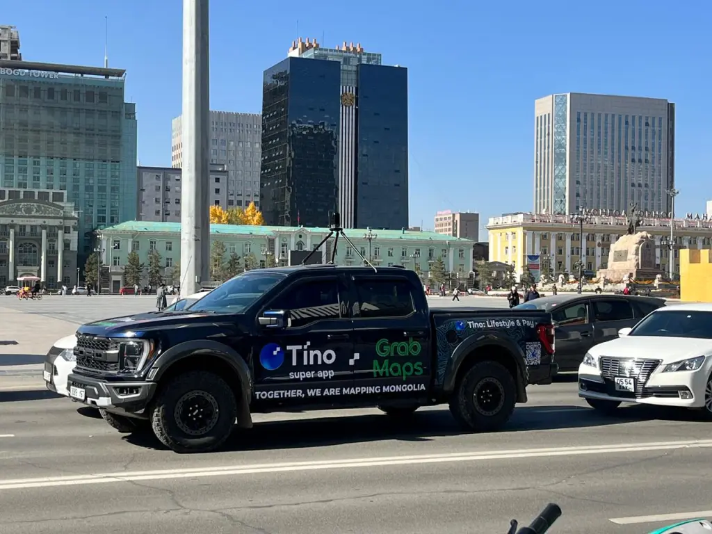
Photo credit: GrabMaps
“Using the same models, we can apply similar logic to our mapping project in Mongolia – rain or snow, we’re able to identify these different weather phenomena,” says Margin. “This makes Grab a lot more versatile in what we can offer to our clients.”
Grab is also bringing its maps beyond navigation. Its collaboration with the World Bank’s Data Development Partnership aims to make effective mapping data readily available to governments, helping to support the development of critical infrastructure such as transport networks and healthcare accessibility.
In Singapore, Grab is working with PUB, Singapore’s National Water Agency, to manage floods, drawing on weather intelligence such as windshield wiper speeds and real-time driver incident reports to help enhance the speed and accuracy of flood monitoring. This has boosted rainfall detection precision in Singapore to 85% to 90%.
Mapping for the future
The rise of generative AI – and Grab’s partnership with OpenAI – has opened up new possibilities.
One of the key opportunities lies in leveraging vision fine-tuning on GPT‑4o, enabling Grab’s AI models to make context-aware decisions. For example, a human can see hazard signs, orange cones, and workers in high-visibility vests, and immediately understand that a road closure is in place – AI is getting there.
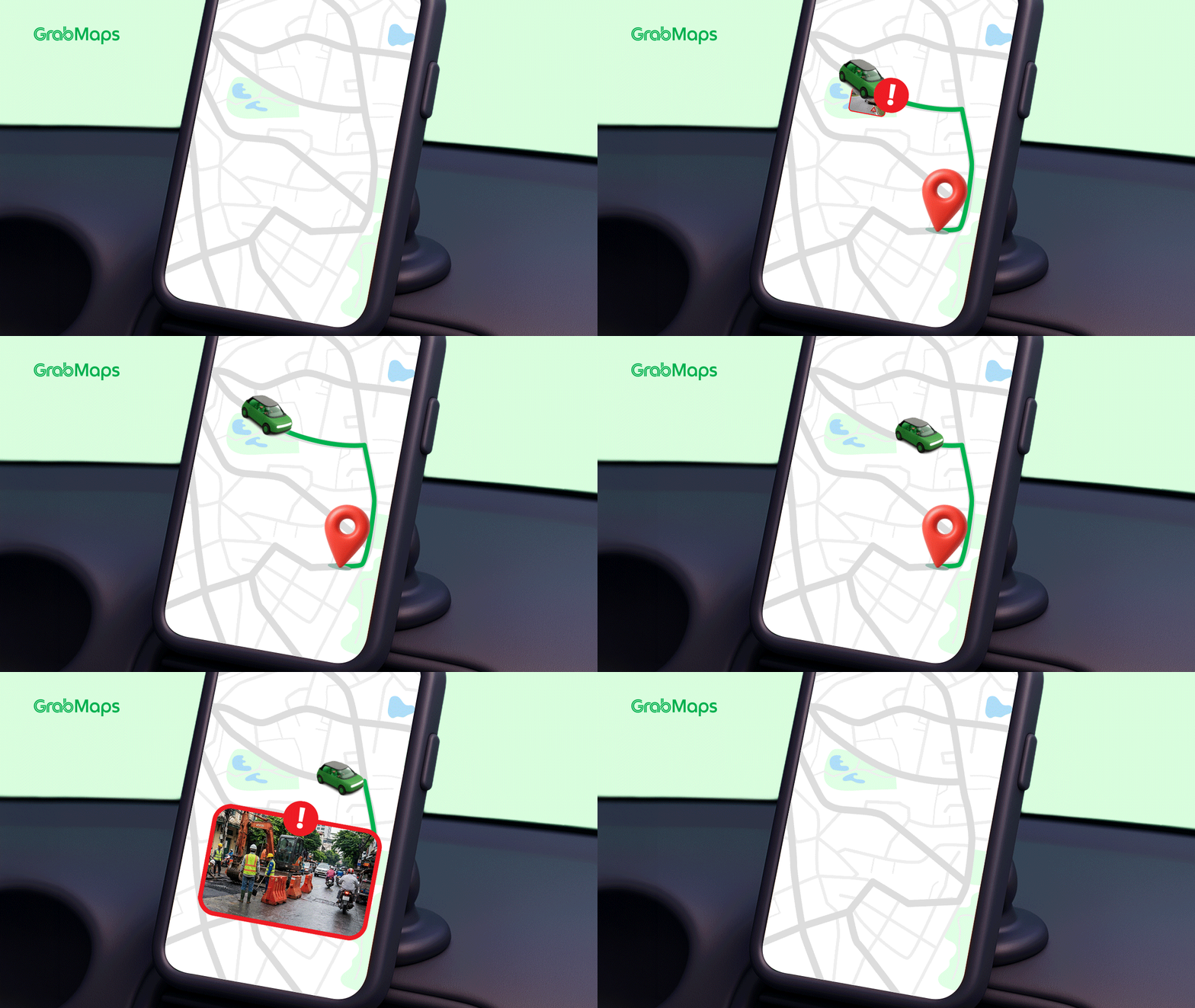
Image credit: GrabMaps
“We’re near a place where these models can help with reasoning for complex situations by providing sufficient context,” says Margin. “This also helps create an ideal reasoning system to incorporate more information and react accordingly.”
With better vision fine-tuning, the models can draw on multiple sources of data to provide context for a situation, much like how a human would compare across different images or reports to draw conclusions and make decisions.
Ultimately, the goal for GrabMaps is to be as accurate to real-world conditions as possible, as fast as possible.
“We want to be able to create a system which can ingest the information in real time, or as close to real time,” shares Margin. “We want to bring the latency down as low as possible, to within a minute or even 30 seconds. That’s the goal.”
GrabMaps provides businesses with intelligent maps and rich, contextual, hyperlocal data, enabling them to solve problems in the real world.
From real-time traffic APIs to street-view imagery and point of interest (POI) data, learn how GrabMaps can help you and your business unlock the potential of maps in Southeast Asia and beyond.
UNLOCK THE POTENTIAL OF GRABMAPS
This content was produced by Tech in Asia Studios, which connects brands with Asia’s tech community. Learn more about partnering with Tech in Asia Studios.
Stay updated on the go with our mobile app.
Get latest insights with smoother, more personalized experience through TIA mobile app.
Recommended reads
 Indonesian AI startup goes global
 Forrest Li on scaling Sea, building smarter bots, and founder grit
 An AI assistant that joins sales calls and scores team skills
 SGX’s CEO says it doesn’t need a unicorn to win
 SMEs want AI too, but not the kind Big Tech is selling
 Oatside’s alt-milk rise hits a profitable gear
 Alibaba’s financial health in 12 charts
 Asia’s telcos bundle AI into mobile plans. Will it pay off?
 M-Daq chases bigger clients as revenue falls, losses grow
 VC tracker: Accel raises US$3.5b, including US$550m for India





Editing by: Winston Zhang, Jonathan Chew, and Jaclyn Tiu
(And yes, we’re serious about ethics and transparency. More information here.)