Nivedita Bhattacharjee · · 3 min read
India’s NASA just launched its own GPS. Here’s why that’s important

An image by NASA. Photo credit: Wikipedia.
On Thursday, the Indian Space Research Organization (ISRO) – the country’s version of NASA – completed the task of developing its own navigation system by successfully launching the satellite IRNSS-1G. The Indians are calling it NAVIC (Navigation with Indian Constellation).
ISRO has already built a reputation of being able to pull off tremendous feats on a budget, and the NAVIC is supposed to be an additional feather in that cap. Here’s a breakdown of how much India spends on space exploration.
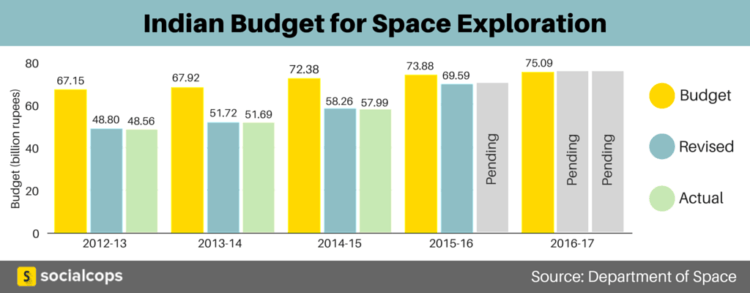
Infographic and data credit: SocialCops.
And here are three reasons why the Indian navigational system is a big deal.
1. Joining an elite club
With NAVIC, India gets a step closer to officially joining a select group of nations that own their own mapping systems. That means it’s also a step closer to potentially making huge breakthroughs in navigation tech and military mapping.

Photo credit: Annie Spratt.
The Indian Regional Navigation Satellite System (IRNSS) is similar to the GPS (global positioning system) of the US.
Other similar programs include Glonass of Russia, Galileo of Europe, and QZSS in Japan. China plans to have its global satellite-navigation system Beidou working by 2020.
While GPS is the global standard of navigation in today’s world, Glonass is also fully functional. The others are either regional or not yet operational.
2. GPS alternative
This technology was developed by the ISRO, which recently put NASA to shame by sending an exploration to Mars that cost less than the budget of the movie Gravity. Given that, one can safely assume that NAVIC will be a more affordable version of the GPS.
Once the system is fully tested (in about a month), NAVIC is expected to provide more accurate and localized visual and voice navigation directions. That’s helpful for everyone, from hikers and travelers to fishermen at sea. It can be used on mobile phones and other gadgets.
3. Military tech




Stay updated on the go with our mobile app.
Get latest insights with smoother, more personalized experience through TIA mobile app.